


Reimagining the future of mountain governance is a pressing challenge that the Mountain Governance Working Group (MGWG) of the MRI is actively addressing through research, collaboration, and partnership-building across various mountain ranges worldwide.
Reimagining the “official future” as perceived within the local and regional mountain governance systems — is a demanding issue in an increasingly uncertain and less predictable global context. Scaling and levelling governance practices across a country’s different regions, or across transboundary regions, are core towards more sustainable futures. Moreover, the degree of decentralisation or autonomy defines the powers, financial resources, technical capacity, etc, available to a specific region. Ultimately, the above allows mountain municipalities and regions to take “ownership”, embed, and tailor external policies and/or joint projects and partnerships into their existing governance systems.
Mountain governance is geo-spatially complex. Natural (e.g., watersheds) or constructed (e.g., administrative) boundaries overlap and form regulatory spaces. This constitutes multi-layered decision-makers. For example, the boundary of a protected area and/or indigenous territories in parts of the world cut through several municipal administrative boundaries within the same or different region(s) and watersheds, and sometimes cross international borders. Localised observation and monitoring systems and geo-databases are key to informing decision-makers and finding consensus between different stakeholders, e.g., GEO Mountains. From another perspective, how can ecosystem services flow be governed between different boundaries and stakeholders?
While remote sensing contributes to spatial strategies (land use, landscapes, open spaces, etc), field and online surveys produce invaluable in-depth knowledge about the political and socio-ecological contexts of global mountain governance systems. As a result, the information and knowledge generated can bring various benefits, including but not limited to effective adaptive governance for climate change, as well as hazard and risk reduction (as shown in Figure 1), which can contribute to building resilience.
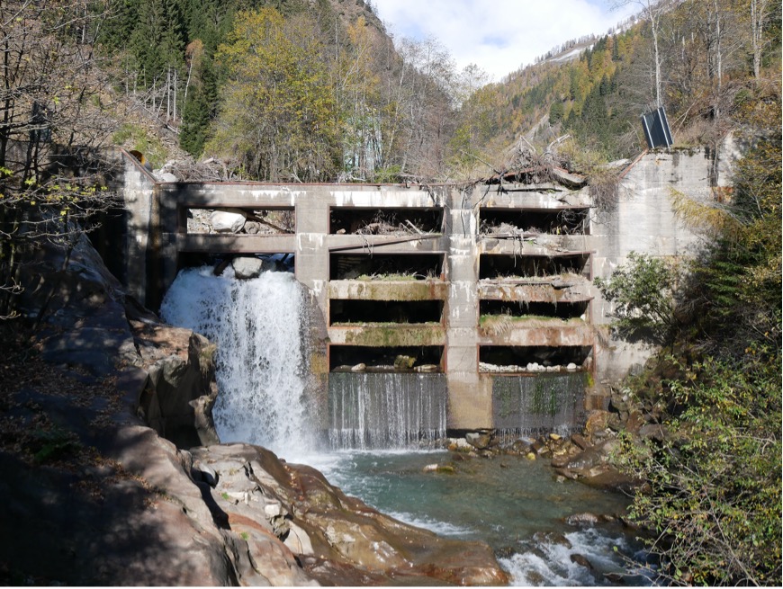
Figure 1: The debris barrier at an elevation of 1,030m ASL, above Moos in Passeier/Moso in Passiria village in upper Passeiertal in Alto Adige/Südtirol, Italy — one of the most unstable valley slopes in The Central Alps, where a landslide caused the formation of the lake “Kummersee” between 1401 to 1774 CE, and historically imposed flood hazard, similar to the contemporary glacial lakes. Note the present large volume of debris delivered by the valley and trapped by the barrier, after passing 60-plus concrete spillways to slow down and prevent the debris from reaching the downstream area. [Photograph by Ahmed Shams, 5 November 2022]
The MRI’s Mountain Governance Working Group (MGWG) continues to build on its six-year research work through a revised and expanded mission statement, to address the above mountain governance complexities. The MGWG produces, analyses, and synthesises information and knowledge about mountain governance, to contribute to the overcoming of global fragmentation within and across different mountain ranges, for example, the Andes, Himalayas, Tibet, Hindu-Kush, Pamirs, Alps, Carpathian, Pyrenees, Ural, Altai, Kanto & Japanese Alps, Caucasus, Taurus, Zagros, Atlas, Hajar, Ethiopian Highlands, etc) — towards scaling and levelling.
The MGWG aims in 2023, 2024-25 and beyond to expand its membership and representation across global mountain ranges, develop partnerships with mountain research institutes, working groups, projects, etc, and participate in global events and conferences. This will allow the working group to design and conduct different field and/or online survey(s) and organise expert-based focus groups, to address multi-dimensional governance challenges.
In this sense, the planned activities will help “reframe a global multifaceted mountain governance” through a better understanding of different mountain governance systems. Reframing helps mountain regions to prepare for and adapt to future evidence-based eventualities — where mountains are transitional geographies, in which accelerating socio-ecological transitions and transformations have a formative impact on the global future.
If you are interested in participating in the Mountain Governance Working Group or learning more about it, please visit our website or join the mailing list here.
Cover image: Several glaciers stem in a star shape from the summit of "Mont Blanc de Cheilon" (3,870m ASL) in the upper-right of the photograph, which is part of the Pennine Alps in Switzerland on the border with Italy. This mountain area is located above the Rhône Valley further downstream. It was captured at the height of the summer from a commercial flight at around 20,000ft when the glaciers are most exposed. The large glacial-fed reservoirs of "Lac des Dix" (upper) and "Lac de Mauvoisin" (lower) in the "Canton of Valais" are clearly visible [photograph by Ahmed Shams, 30 August 2011].
