

 Submissions to the recently launched MDPI Remote Sensing Special Issue on 'Remote Sensing of Glaciers at Global and Regional Scales' are now open.
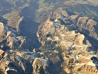
 The Remote Sensing Special Issue on 'Remote Sensing of Glaciers at Global and Regional Scales' aims to provide a comprehensive overview of recent and upcoming advances in the application of satellite remote sensing to monitor changes in the state of the Earth's mountain glaciers and ice caps at regional and global scales. This excludes the main ice sheets of Antarctica and Greenland, but studies focusing on their peripheral glaciers and ice caps, including the Antarctic Peninsula, are welcome.
Potential topics include, but are not limited to:
- Variations in the volume and mass of glacier regions from gravimetry, altimetry, photogrammetry, etc.
- Changes in their extent and surface properties (such as surface albedo).
- Changes in the flow behavior of glacier regions, e.g., surface velocity and discharge.
- First results from recently launched satellites (e.g., ESA's Sentinels) and the potential of upcoming missions (e.g., ICESat-2, GRACE-FO).
- Multi-platform merging and the combination of satellite observations with historical data sources.
- Integration and assimilation of satellite remote sensing data into Earth system models.
- Novel applications of data processing, such as machine learning and 'big data' analysis.
More information about this special issue and how to submit your manuscript can be found on the Remote Sensing website.
