

GEO Mountains is pleased to announce the release of a new global dataset on Multilateral Environmental Agreements (MEAs) in mountain regions. This unique resource provides a comprehensive spatialised classification of MEAs and their country memberships.
What’s in the dataset?
The dataset integrates metadata from over 1,400 MEAs sourced from the International Environmental Agreements Database (hosted by Université Laval) with global mountain delineations and country-level spatial data. Each MEA has been systematically classified into three levels of mountain relevance:
- Level 1 (Mountain-specific): MEAs explicitly targeting mountain ranges or ecosystems (e.g., Alpine Convention, Framework Convention on Environmental Protection for Sustainable Development in Central Asia)
- Level 2 (Potentially mountain-relevant): MEAs applicable to terrestrial environments that implicitly include mountainous areas
- Level 3 (Potentially non-mountain-relevant): General environmental MEAs without mountain or terrestrial focus
The dataset includes geospatial layers for all treaty memberships at the country level, plus detailed mountain-specific coverage for Level 1 MEAs. Users can visualise which countries with mountainous territory are signatories to specific MEAs, explore patterns of treaty adoption, and analyse the integration of mountains into international environmental frameworks.
Key features:
- Over 1,400 MEAs classified by mountain relevance
- Geospatial layers for each MEAs showing signatory countries
- Mountain-specific spatial coverage for 25 Level 1 MEAs
- Country-level statistics on MEA participation
Prototype interactive map:
To enhance the visualisation of the classified MEAs, we have developed a prototype interactive map. This map allows users to click on a country and view all MEAs signed by that nation, along with relevant statistics for each country. Currently, the visualisation of MEA memberships is in development, with future plans to enable users to visualise the membership for each individual MEA.
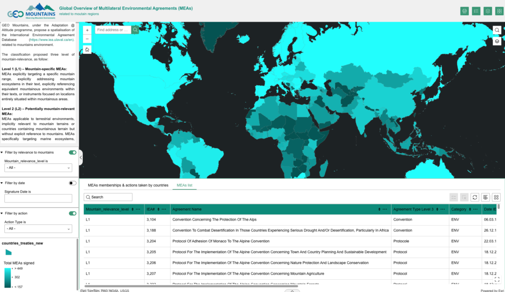
The web map is available here. Users can also filter and download the data directly from the map.
Access and use:
The dataset is freely available under Creative Commons Attribution Non-Commercial 4.0 International licensing via Zenodo (10.5281/zenodo.18386085). Full documentation, including methodology and data sources, is provided in the accompanying readme file.
Users are required to cite the dataset along with the original International Environmental Agreements Database and the foundational publication by Mitchell et al. (2020) in Global Environmental Politics.
This is the first version of the dataset and web map published. If you have any comments, suggestions, or if you encounter any issues or bugs, please reach out to us at geomountains@mountainresearchinitiative.org.