

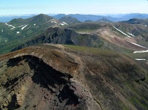
 Fig. 1: Mount Asahi-dake (2,291 m), the highest peak in DNP, in the foreground, and the Ohachi-daira caldera in the center (Photo: TW)
Daisetsuzan National Park (DNP), located in central Hokkaido, a northernmost island of Japan, is Japan’s largest national park (226,764 hectares). Residents in the city of Sapporo with 2 million populations can access the park area in 2.5 to 3 hours by car, and can enjoy hiking/trekking and hot springs in the park’s volcanic landscape (Fig. 1). In spite of its close location to such a large city and in site of the large number of visitors, DNP is home to densely populated brown bears.
New challenges are now emerging and addressed in DNP. Among them are offering learning opportunities to visitors and involving local stakeholders in the park management. However, most information is available only in Japanese, as most research publications (>2,800 in total) are written in Japanese. Here, I will briefly introduce these new actions and opportunities in the national park.
Creating geoparks and learning opportunities
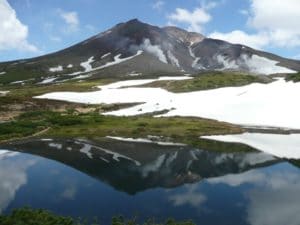 Fig. 2: Alpine landscape of Daisetsuzan National Park in late June (Photo: TW)
As a literal translation of Daisetsuzan is ‘great snowy mountains’, the park receives large amount of snow, which covers the high altitude area from October to June (Fig. 2). There are various kinds of volcanic landforms. On the ground surface at high altitudes, periglacial landforms such as sorted polygons, solifluction lobes, earth hummocks, turf-banked terraces, and palsas are developed, and the existence of permafrost (maximum thickness>15 m) has been recognized since the 1960s. Theses characteristics provide DNP great potentials to geotourism development. In fact, a part of the south of the national park was recognized as Tokachi-Shikaoi Geopark in 2013. Local school kinds and their parents as well as outside visitors have opportunities to learn about the volcanoes and permafrost, relationship between agricultural products and the soil originated from the volcanic deposits. Further, a few more geoparks are preparing to be endorsed by the Japanese Geopark Network. The creation of geoparks is expected to strengthen ties between the national park authority and the local communities through the development of geotourism and ecotourism.
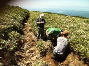 Fig. 3: Tour to measure trail erosion near Asahi-dake
The participants also receive lectures by university professors on the erosion process and on basic treatment of the data obtained by a drone (UAV) in the field to understand 3-D trail morphology (Photo: TW)
Involvement of local stakeholders toward challenges in the national park
The Ministry of the Environment, the responsible organization in the national park management, identifies many challenges in the national park area. One of the challenges is severe trail erosion by human trampling. The rapid erosion has become evident since the end of the 1980s. Maintaining and repairing the degraded trails require big budget and great manpower. The ministry, together with the local stakeholders, created a body to maintain and repair the trails by themselves.
Furthermore, another address to the trail degradation has appeared as a new type of tourism, i.e., trail erosion measurement tours (Fig. 3). Such tours are organized by the local mountain guides with the support from the local township.
Trail maintenance tours (Fig. 4) are also conducted. Local alpine clubs and the Ministry of the Environment occasionally collect citizens from various areas in Hokkaido to get helps to carry necessary materials to repair and maintain trails.
The long trekking courses called the Grand Traverses (north and south courses) are quite popular among international trekkers because they are described in Lonely Planet, Hiking in Japan. However, they may not be so easy as many international trekkers believe. Such a belief is related probably to the limited information in English and to the low elevations of the mountains. However, the park area is under severe alpine climate, and in fact it even has permafrost at its high altitudes as stated. There are many accidents with some death toll every year. International trekkers are not exceptions.
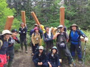 Fig. 4: A tour to carry necessary materials to repair and maintain trails (11 August 2017)
This tour was organized by the Ministry of the Environment as an activity on the Japanese Mountain Day (a national holiday on every 11 August), which was started in 2017 after long discussion and preparation initiated by the International Year of Mountains. This type of volunteer activities is increasing in Daisetsuzan National Park (Photo: TW).
To avoid such unfavorable results, the Ministry of the Environment has launched the Daisetsuzan Grade (DG) for both international and national trail users. The DG consists of five levels from Grade 1 to Grade 5. This grade system was introduced for the first time as a measure by the ministry with the help by the local stakeholders including university researchers. The grade system is different from many of the similar systems in other countries because it was decided not only by easiness/difficulty of trails but by the degree of vulnerability of the nature. The DG is described in the English map entitled ‘Asahi-dake, the heart of the Daisetsuzan National Park’, which was published in April 2017 (Fig. 5). It has a 1:25,000 topographic map on one side and the description on the essentials of the park, such as landform, geology, fauna, flora, national-park regulation, tourism facilities on the other side. The map is available at Geckomaps (http://www.geckomaps.com/) or Amazon Japan (ISBN-10: 4906740278, ISBN-13: 978-4906740277).
The most popular trekking course (Between Asahi-dake Onsen via Kuro-dake Ishimuro and Sounkyo Onsen)
This course is for one-day trek. Otherwise, you may stay overnight at the Kuro-dake Ishimuro campsite or hut (you need to bring your sleeping bag, food and cooking gear). Immediately after riding a gondra ropeway from the Sanroku station in Asah-dake Onsen to the Sugatami Station, you will reach an alpine belt. Various kinds of alpine flowers, dwarf pine trees (Pinus Pumila) and long-lasting snow patches show their mosaic patterns (Fig. 2), which are created by the uneven distribution of winter snow (from 0 m to 30 m in depth) due to extremely strong winds. The long-term studies by Prof. Gaku Kudo of Hokkaido University clearly shows that the distribution patterns of some alpine plant species are now rapidly changing under increasing temperature and enhanced dryness.
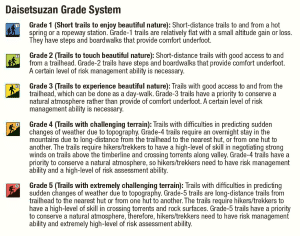 Fig. 5: Classification of the Daisetsuzan Grade (from the English map, Asahi-dake, the heart of the Daistsuzan National Park)
The five grades were decided by the matrix of the combined factors of easiness/difficulty of trails and of degree of vulnerability of soil/alpine vegetation, although the degree of vulnerability is not shown for easy use.
To the summit of Asahi-dake, you need to negotiate the steep ascending trail, observing active fumaroles and many small ponds on the craters. Panoramic view from the summit must astonish you. To the east, you will find Ohachi-daira caldera (ca. 2 km in diameter, Fig. 1). After passing the caldera, you will reach Mount Kuro-dake (1,984 m), and will start descending to the char-lift station (Nanagoume) and then to the gondra ropeway staton (Kuro-dake Station). You can see the present topography of deep gorge around Sounkyo, which is the product of stream erosion since the last 34,000–40,000 years. Gigantic phyroclastic flow derived from the eruption at the Ohachi-daira caldera had filled downvalley covering vast area, including the locations of the current settlements of Sounkyo and Kamikawa. The exposed columnar joint can be observed on both sides of the gorge around hot spring of Sounkyo.
In the past recent years, the park has attracted increasing number of international tourists and trekkers. You can be one of the future visitors to Daisetsuzan National Park. Daisetsuzan has been worshipped as ‘playground of gods’ by Ainu people, a minority tribe in Japan. You are always welcome to visit, enjoy, and learn this mountain national park.
This post has been written by Teiji Watanabe, Professor at the Faculty of Environmental Earth Science of Hokkaido University in Sapporo, Japan.